Lunar Exploration for Resource Utilization
Michael B. Duke
The strategy for developing resources on the Moon depends on the stage of space industrialization. A case is made, in part 3 of this volume, for first developing the resources needed to provide simple materials required in large quantities for space operations. Propellants, shielding, and structural materials fall into this category. As the enterprise grows, it will be feasible to develop additional resources-those more difficult to obtain or required in smaller quantities. Thus, the first materials processing on the Moon will probably take the abundant lunar regolith, extract from it major mineral or glass species, and do relatively simple chemical processing.
Little additional information on ore availability, beyond what was learned in the Apollo Program, is necessary to plan these early steps. Nevertheless, there are classes of information that need to be obtained before we actually develop lunar resources and a lunar base. We need to conduct a lunar remote sensing mission to determine the global distribution of features, geophysical properties, and composition of the Moon, information which will serve as the basis for detailed models of and engineering decisions about a lunar mine.
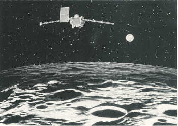
A satellite placed in low lunar polar orbit for a year or more can completely map the Moon in several ways. Such a mission, lunar polar orbiter, has been proposed for 15 years, and the desirable complement of instruments for it is relatively well defined. See figure 2.
The combined data set from a lunar polar orbiter would serve to upgrade our understanding of the Moon and its geological evolution. The better we understand that evolution, the better we will be able to predict where to look for valuable resources.
The first contribution of such a mission would be to obtain additional images of the Moon, a process which was left incomplete by the Apollo Program. Past plans for lunar orbiters have not stressed high-resolution image data; however, such imagers have been proposed in more recent concepts of this mission. The instrument will probably be a charge-coupled device (CCD) imager.
Figure 2
Lunar Observer
A spacecraft orbiting the Moon around its poles, the Lunar Observer,
would map the chemical composition of the entire Moon, at a resolution of a
few hundred meters. At that resolution, it will be possible to locate areas
that are rich in particular lunar minerals, like ilmenite (FeTiO3), and to check
the idea that water ice may be trapped in polar cold spots. The Lunar Observer
will improve general geological modeling of lunar resource distribution, but
the presence of the lunar regolith, which has somewhat homogenized the uppermost
surface, will make difficult the detection of specific ore bodies from lunar
orbit. Besides such mining information, the Lunar Observer would also gather
a broad range of useful scientific information.
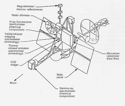
Several geophysical instruments-a combination magnetometer and electron reflectometer, a radar (or laser) altimeter, and possibly a microwave radiometer-would gather important geophysical data.
Using x-ray and gamma-ray spectrometers, at a resolution of 1 to a few kilometers, this mission would provide a map of the chemical constituents of the lunar surface. If, as has been speculated, there are concentrations of water in permanently shadowed regions near the lunar poles, the gamma-ray device should be able to detect them. These data will provide information on the global distribution of rock and soil compositions but will not pinpoint small ore deposits, because the lunar regolith has been thoroughly mixed by eons of meteoroid bombardment.
A visible and infrared mapping spectrometer would take spectra of known points on the surface to provide mineralogical data at a finer scale. The results would be low-resolution spectral images of the surface. A thermal infrared emission spectrometer would gather spectra of a longer wavelength, which can be interpreted in terms of surface mineralogy of targeted points, but it would not produce images. This instrument might be upgraded to an imaging spectrometer if technology and costs allow its development.
Although the resolution of chemical mapping by a lunar orbiter may not be high, there are questions of site selection for a processing facility that can be addressed with orbiter data. For example, we know that there are titanium-rich basalts and soils and that there are likewise aluminum-rich anorthosites and soils. Our knowledge of where both types of materials can be accessed readily is less certain. If we plan to develop a lunar facility that depends on the availability of both titanium and aluminum, the lunar orbiter may be able to discover optimum locations.
Geochemical anomalies (ore bodies) may be difficult to locate directly with a lunar polar orbiter. However, some ore deposits may be related to geophysical irregularities. For example, there is a significant magnetic anomaly in the vicinity of the crater Reiner Gamma. The explanation of the anomaly is not in hand, but further exploration of it and similar anomalies, if they are found, may lead to the discovery of new resources. In general, the correlation of chemical and geophysical data should be pursued.
There are a number of issues related to the operation of a lunar base and its resource extraction facilities for which additional image information would be desirable. These include questions of engineering feasibility, surface trafficability, safety, ease of working with the regolith, availability of slopes, and soil cohesiveness. As part of a lunar polar orbiter mission, images with resolution of a few meters should be obtained for areas under consideration as sites for lunar bases.
A lunar orbiter can provide information to establish the surface characteristics of the Moon before extensive human activities there. Because of the static nature of the lunar surface under natural conditions, human activity on the Moon will inevitably change the environment. It will be important to obtain global maps before that stage of development, both to serve as a baseline for further survey work and to record a state that will be changed irreversibly.
![[NASA]](images/NASAball.gif)
![[Ames Research Center]](images/arclogo1.gif)
|
WebWork: Al Globus, Bryan Yager, and Tugrul Sezen |
![[LifeSciences]](images/lslogot.gif)
![[Space Settlement]](images/splogosm.gif)
|